Orbis Multiplex
Version 0.0.9
Summary
It's been a while since the last devlog here, previous devlog can be found at Youtube.
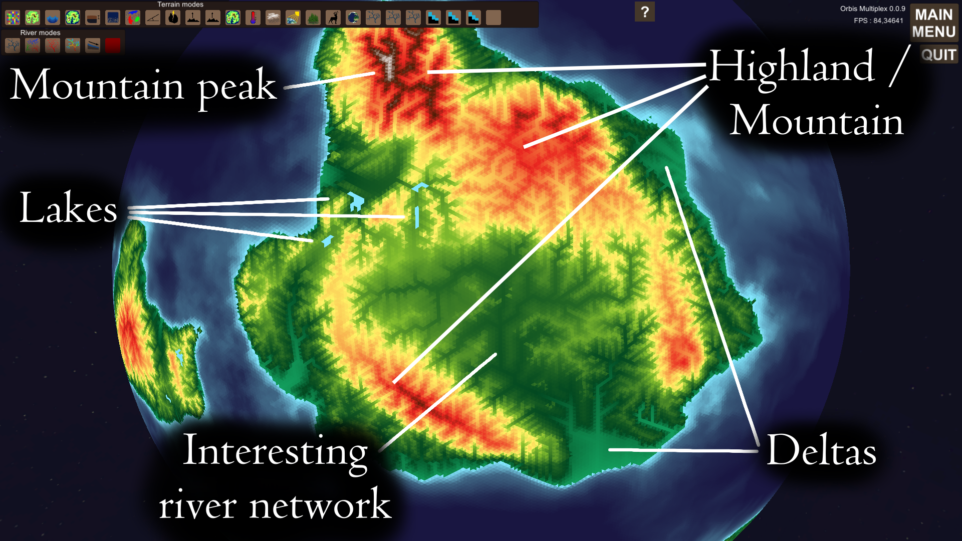
I recently improved the map generation of the project. I use perlin noise to create an initial primitive map. I then apply tectonic uplift (also from perlin noise) and hydraulic erosion to create interesting continents.
The hydraulic erosion is based on simulating water as fields. Water is created through precipitation. Flows into adjacent cells. Erodes/deposits sediment dependent on slope and water speed.
The algorithm creates interesting branching river networks, and some deltas. From a gameplay perspective these deltas and river networks will be interesting. The soil of deltas would be highly fertile which would provide civilizations with excellent farm land. The branching river networks will also be interesting. The rivers could serve as routes for trade, or provide valuable fresh water. Large rivers could also serve as natural barriers between different regions. Forming natural borders between kingdoms.
At the moment the tectonic uplift map used isn't the best. It's currently based on perlin noise, to geta more realistic uplift a proper tectonic simulation should be implemented. The current uplift gives mountain ranges in weird places.
To know more about what I've been doing since the last devlog; check out this video.
To do
- Better tectonics. With a proper tectonic plate simulation the shape of continents would be mor realistic. And mountain ranges would appear in logical places where plates collide for example. Volcanic island chains could also be simulated which would be interesting.
- Vegetation - erosion interction. At the moment the ecosystem simulation and the world generation is completely seperate. It would make sense that vegetation grows better in places with lots of sediment. Thicker vegetation should also slow down the flow of water, reducing the effect of erosion.
- GUI overhaul. The selection of map filters isn't very intuitive at the moment, this should be improved. It's also not clear what the colourmaps represent. The elevation colourmap goes from shades of green -> yellow -> red -> brown -> white. In the program you can't see this order, nor can you see that white represnts 8000 meters and that yellow is 1500 m. This needs to be displayed to the user.
- Realistic rain patterns. At the moment precipitation is determined by latitude and some perlin noise. In the future i would like to implement a proper wind pattern simulation. This would great more intersting rain patterns. Rain shadows behind mountains could for example be added.
- Gameplay. The world generation has come a long way, at it might soon be time to start add some gameplay. Initial gameplay would consist of the ability to harvest tiles for resources; wood and meat through logging and hunting. A simple production chain involving a farm, lumber camp and settlement shoudl be added. Resource transportation would also need to be simulated. Road networks might not be top priority, so that will most likely be added at a later stage.
Files
Get Orbis Multiplex
Orbis Multiplex
A complex simulation oriented strategy and management game on planetary scale
| Status | On hold |
| Author | Robin Johansson |
| Genre | Simulation, Educational, Strategy |
| Tags | 4X, Automation, Economy, Generator, Management, Procedural Generation, Singleplayer |
| Languages | English |
More posts
- Generating hexagonal meshes on spheresAug 14, 2022
- Hexagonal grid | 0.2.0.0Aug 07, 2022
- Automatic tick progression | 0.1.6Mar 25, 2022
- Transportation network | 0.1.5Mar 09, 2022
- Ground water diffusion from rivers | 0.1.4Feb 18, 2022
- Updated landscape evolution algorithm | 0.1.3Feb 03, 2022
- Minor industry additions | 0.1.2Jan 28, 2022
- Industry production added to gameplay | 0.1.0Jan 26, 2022
- Version 0.0.11Dec 19, 2021
- Version 0.0.10Sep 24, 2021
Leave a comment
Log in with itch.io to leave a comment.